© Sam Birch

© Sam Birch

© Sam Birch

© Sam Birch

© Sam Birch

© Sam Birch

© Sam Birch

© Sam Birch

© Sam Birch

© Sam Birch


The calm after the storm in Les Arcs
Blizzards, high winds, fog, storms and tons of snow
It has been quite a week on the pistes. We have seen practically every type of weather imaginable, often on the same day. Typically it has been cloudy, although inversions have been possible at times, and there has been nigh-on constant snow since the New Year’s weekend.
The freezing level has yo-yo’d from the valley floor to just over 2000m, with temperatures shifting dramatically throughout the day: some days have started mild, turned suddenly cold, warmed up again and frozen as the night sets in. This has made the weather, skiing conditions and general life on the mountain extremely unpredictable. On Wednesday, there were national weather warnings due to the anticipated “monstrous” snowfall and strong gale-force winds felt across the Alps. In some places above 2000m, there has easily been an extra metre of snow registered in the last five days. It has regularly dumped snow in Bourg St Maurice (800m) yet, on at least one occasion, this was followed by rain above 1600m.
Skiing this week has therefore been a very mixed bag, with often excellent, powdery conditions on piste created by the almost incessant snowfall. This is doubly good news, as the capricious weather saw the avalanche risk upgraded from 3 (considerable) to the maximum level, 5 (very high/extreme). Off-piste skiing and snowboarding was therefore not recommended, with even fairly moderate slopes being susceptible to avalanches. Today, however, the weather has begun to settle down and we are returning to a particularly snowy reality.

Lifts
Many sectors have been inaccessible since Wednesday, with the unstable snow base making lift closures necessary for safety reasons. On Thursday, less than half of the ski lifts were running with both high-level chairlifts from Arc 1600 (Cachette and Mont Blanc) lying dormant. Peisey-Vallandry was one of the least-affected resorts, with the majority of lifts staying open: the proliferation of tree-lined runs and heavily wooded areas in this area seriously reduces the chance of snowslip whilst the directional aspect diminishes the effect of the wind. In Arc 1600, the longest open lifts were Charmettoger and the first half of the Transarc. Only a handful of shorter lifts were open in the Arc 2000/1950 bowl.
Fortunately, by midday on Friday, many of the previously closed lifts had reopened, making it possible to travel over the Col des Frettes from Arc 1800 to the Arc 2000 bowl, and back again via the Col de la Chal. The pistes are particularly busy around Arc 1800 (and the Carreley chairlift), which is probably because people are making the most of the final day of the week, having seen disruption on Wednesday and Thursday. The avalanche risk has been downgraded to 4 (high) and more lifts seem to be reopening every hour.

Conditions on piste
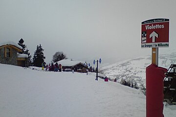
There is currently a bit of everything and, although the meteorological situation is beginning to calm down, we are likely to see wildly varied conditions underfoot over the weekend. In general, the top layer is surprisingly pleasant, quite soft but without being sludgy. This is mainly noticeable in the lower regions (1400-1800m) where recent snowfall has been wetter and sometimes sleety. The riding is therefore largely comfortable and smooth, although some softer faux-moguls are beginning to form where the inclination is slightly more severe. In some areas, such as the Violettes and Granges red runs around the funicular, the pistes are looking a bit brown; this is actually largely cosmetic, as the snow base is rather exceptional everywhere, and mostly caused by the recent wind blowing debris from the surrounding trees.

Good news
You cannot have blizzards without having snow, and snow is always welcome. Although temporary piste closures were inevitable following the exceptional weather we have experienced at the start of this year, the snow base has continued to rise and every part of the mountain, from valley level (800m) upwards, is coated in a thick layer of the magical white stuff. The wind, which has been successively pushing an assortment of weather fronts through the Alps, has already died down and should remain moderate over the weekend. This will encourage more regular temperatures and, in turn, lead to more stable conditions throughout the resorts. In the meantime, the ski domain’s pisteurs will be working hard to clear any avalanche hotspots and otherwise convince the snow to act more predictably. It is already evident, where snow had shifted onto the runs, that piste-bashers have been through and cleaned up. The cloud has largely broken up, although visibility is not yet ideal but we should see some clear spells on Saturday and periodically through next week. January is traditionally a quiet month on the slopes of Les Arcs so you can expect plenty of snow, and room to enjoy it, in the immediate future.


